Iceland Volcano: Magma Beneath Svartsengi Continues To Accumulate
Updated 25 November 2025
Key Points
The rate of magma accumulation beneath Svartsengi has remained fairly stable over the past two weeks
The likelihood of a magma intrusion and an eruption remains elevated in the coming weeks
It is not possible to estimate the timing of the next eruption with greater accuracy than within a few months
The hazard assessment remains unchanged until 9 December
Assessment of the likelihood of a new magma intrusion and eruption based on modelling results
Uplift and magma accumulation beneath Svartsengi continues. The rate of magma inflow has remained relatively stable over the past two weeks. Modelling results indicate that approximately 16–17 million m³ of magma has accumulated beneath Svartsengi since the last eruption in July.
The amount of magma that intruded from Svartsengi into the Sundhnúksgígar crater row during the eruption that began on 16 July was estimated to be around 11–13 million m³. Based on previous eruptions along the Sundhnúkagígar crater row, the likelihood of a new magma intrusion and eruption is thought to increase once roughly the same volume of magma has reaccumulated beneath Svartsengi as was withdrawn during the preceding event.
In early October, modelling results indicated that about 11 million m³ of magma had reaccumulated beneath Svartsengi. At that time, a period began—still ongoing—during which the likelihood of a new magma intrusion and eruption is considered elevated.
Slower magma accumulation increases uncertainty in the timing of the next event
In the lead-up to eruptions along the Sundhnúksgígar crater row, the rate of magma accumulation has varied. The current magma inflow into the storage area beneath Svartsengi is estimated at around 1 m³/s. Modelling of geodetic data shows that the overall inflow rate has gradually decreased over time since the start of the activity in 2023. The slower the accumulation, the more difficult it becomes to estimate the timing of the next eruption. Based on current knowledge of the eruptions along the Sundhnúkagígar crater row, it is not possible to predict the timing of the next event with accuracy greater than a few months.
Experience from recent events has also shown that the accumulation rate does not need to change much for the timing of the next possible eruption to shift by several weeks. Uncertainty in the timing of the next event is therefore considerable, and the current magma accumulation period could continue for an extended time.
The magma volume recharged to the Svartsengi reservoir prior the past four events in Sundhnúks crater row has been assessed to have an upper bound of 23 millions m3. If a similar volume needs to be recharged before the next dike or eruption is triggered, and assuming the current accumulation rate remains unchanged, then this upper bound volume would be reached by early February 2026. The following graph illustrates the magma accumulation beneath Svartsengi since the most recent eruption along the Sundhnúkagígar crater row.
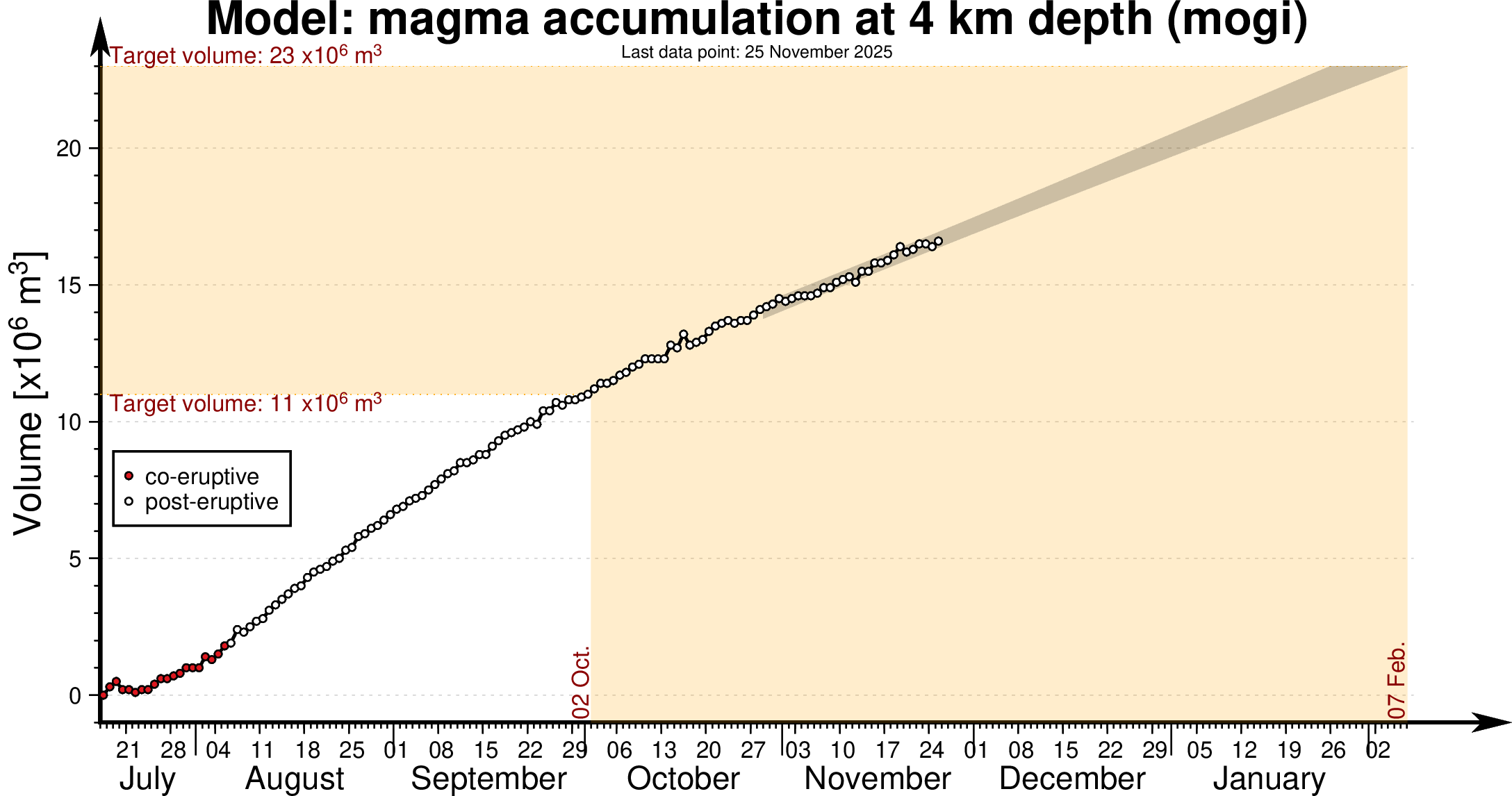
Model of magma accumulation at 4 km depth beneath Svartsengi since 17th July. The black circles show daily measurements of magma volume from July 2025 to the present day. The shaded area represents a forecast of magma accumulation at a constant inflow rate, while the red dashed line indicates a likely trend if the inflow rate continues to decrease. The volume thresholds of 11 and 23 million cubic meters are estimated model bounds for a potential magma intrusion and eruption.
Seismic activity at Svartsengi and krýsuvík
Seismic activity continues to be low at Svartsengi and Grindavík. Seismicity at Krýsuvík continues to decrease, and deformation measurements indicate that land subsidence at Krýsuvík has ceased.
Hazard assessment
The hazard map remains unchanged until 9 December. The Icelandic Meteorological Office will continue to monitor developments closely and update the assessment if changes occur in activity.
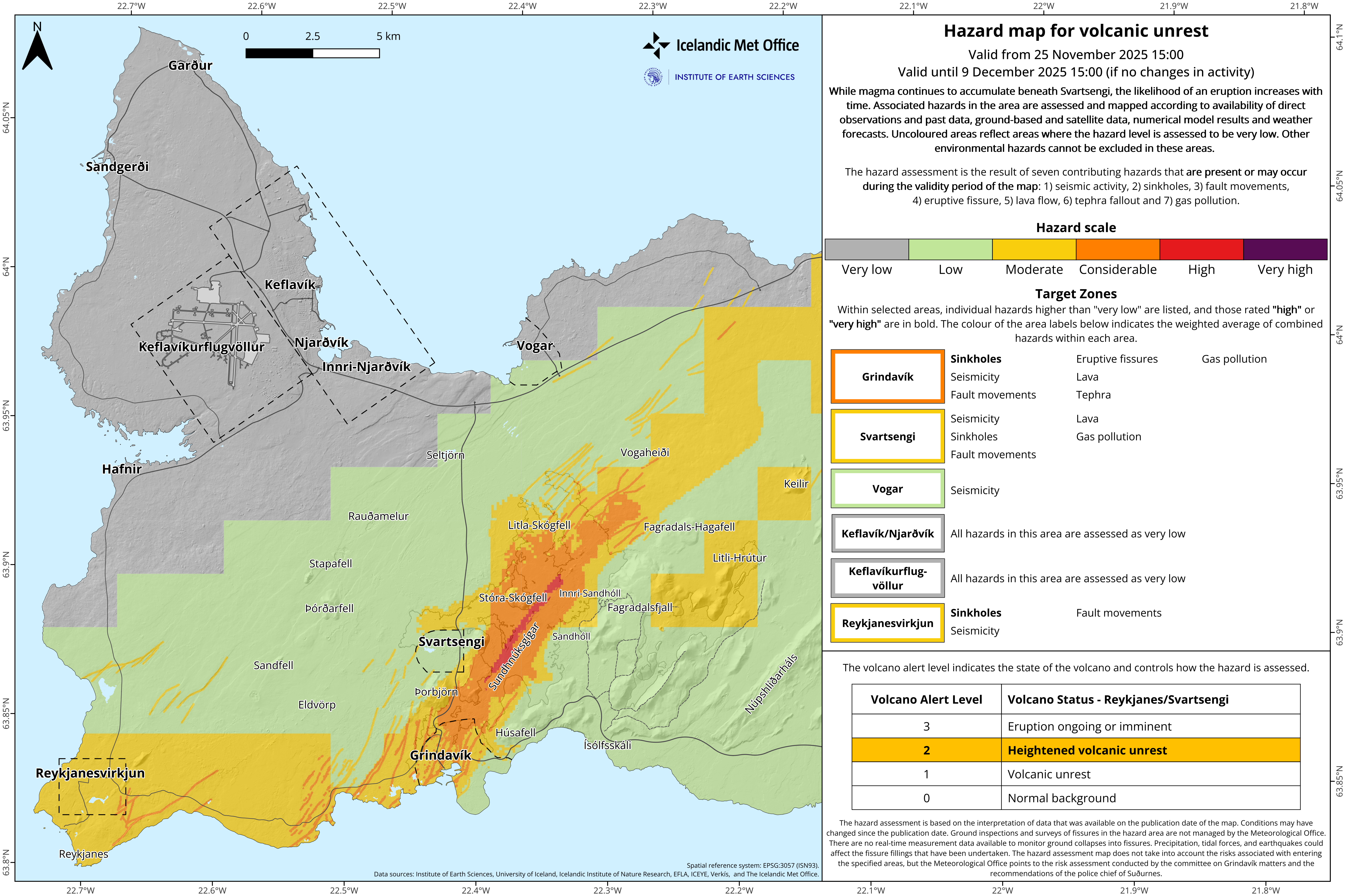
Two changes have been made to the visualization of "Target zones". The names of the zones have been changed from numbered zones to location name and the outlines of the zones are now defined as a dashed line instead of a solid line.
- CategoriesEdited | Earthquakes | All Content | Volcanos | Government | Science | Europe | News | Analysis | News -- WNT Selected | Text | Images
- Date rangeTuesday, November 25, 2025
- Last modifiedTuesday, December 16, 2025
