Iceland Volcano: Ongoing Magma Accumulation And Land Rise In Svartsengi -- Iceland Met Office
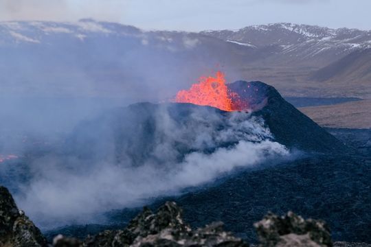 Volcano eruption at Sundhnúkur. Photo taken 10. April 2024 by Jón Bjarni Friðriksson/IMO
Limited activity in the crater
Updated 7. May at 17:45 UTC
Land rise continues in Svartsengi
The rate of magma accumulation remains similar to that observed in recent weeks
Visible activity in the active crater has decreased in recent days
There is a growing likelihood that the current eruption may increase in intensity or that a new eruptive fissure may open
Warning of increased volcanic activity or a new eruption could be very brief
The gas dispersion forecast can be followed here
The hazard assessment remains unchanged
The eruption at the Sundhnúk crater row continues. Lava continues to flow a short distance from the active vent, but activity within this crater is decreasing. Over the past week, little to no change has been observed in the southern part of the lava field near the defensive barriers east of Grindavík.
Magma accumulation and land rise continue in Svartsengi. The rate has remained consistent in recent weeks (see figure below). These measurements indicate that pressure continues to rise in the magma chamber. Therefore, a new dike intrusion from the magma chamber beneath Svartsengi towards the Sundhnúk crater row remains possible.
Seismic activity has increased steadily in and around the eruption area over the past week. Most of the earthquakes, which are generally smaller than magnitude 1, are located north of the current eruption site, between Sundhnúk and Stóra Skógfell, south of Þorbjarnar in the large valley near Grindavík, and between Grindavík and the current eruption site. This gradual increase in seismic activity is likely a sign that stress is being released around the eruption site on the Sundhnúk crater row due to increased pressure in the magma chamber beneath Svartsengi.
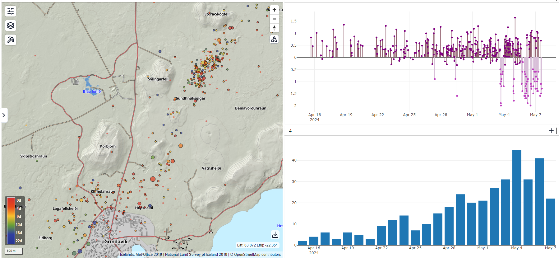 This figure shows a map with the locations of earthquakes since April 15th (left), along with automatic magnitudes (top right) and the number of earthquakes per day (bottom right).
These are the most likely two scenarios regarding the continuation of activity at the Sundhnúkur crater row:
- New eruptive fissures could open in the area between Stóra-Skógafell and Hagafell, and/or the current eruption site could expand due to a sudden increase in lava flow, which may be comparable to the initial phases of the last volcanic eruption in the area. This could occur with very little to no warning.
- It is also possible that the flow of magma from the magma chamber beneath Svartsengi into the active vent at the Sundhnúkur crater row may increase steadily until there is equilibrium between the inflow of magma into the chamber and the outflow onto the surface.
Signs of a new volcanic eruption would likely include a sudden increase in earthquakes in and around the eruption area, an acceleration in deformation, and pressure changes in nearby boreholes. It is important to understand that warning times could be nonexistent or very short, possibly less than half an hour.
The hazard assessment remains unchanged since the last update. In the past week, the risk of possible active lava flows in area 4 (Grindavík) has increased from considerable to high, based on the scenarios now considered most likely.
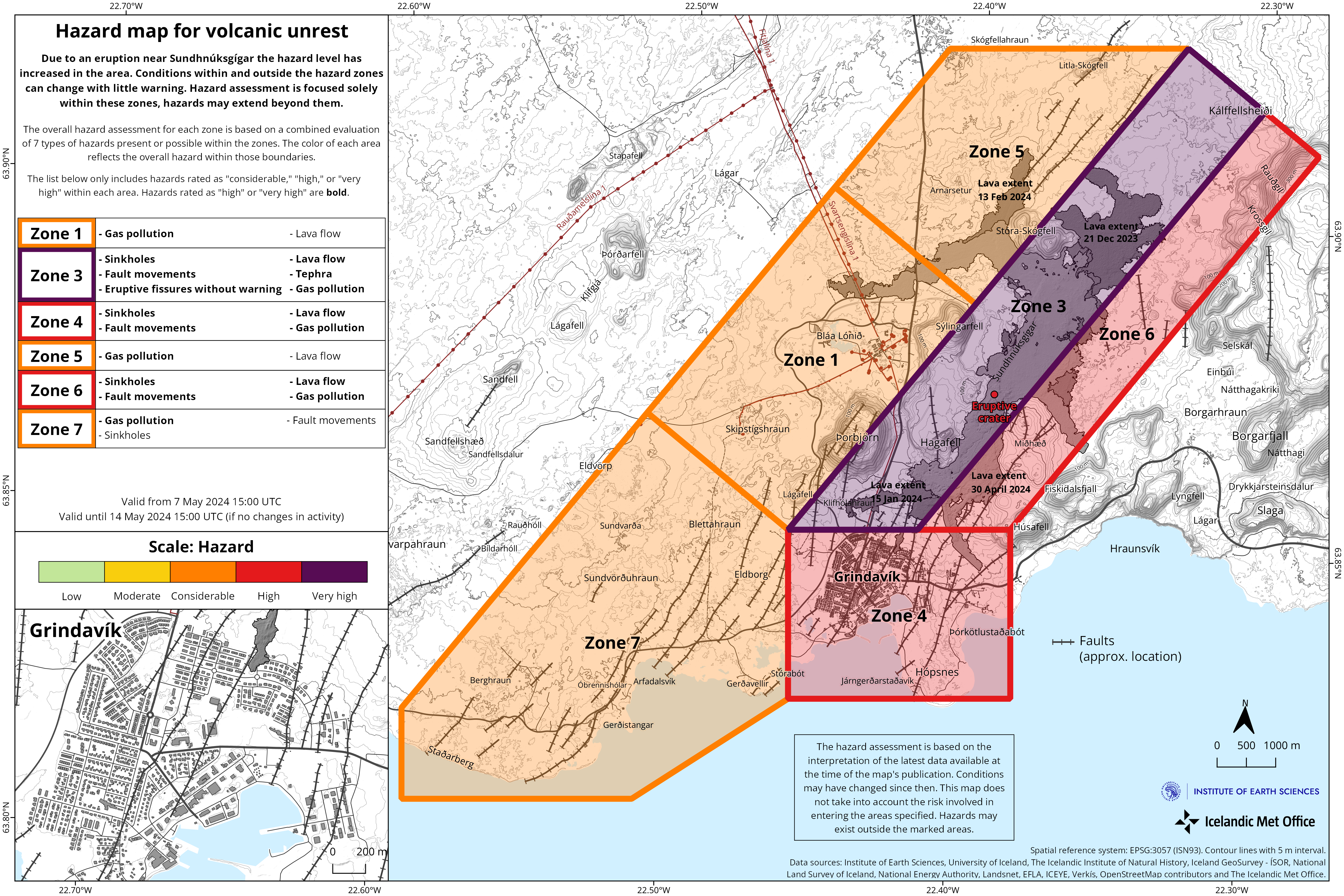 (Click on the map to see a larger version)
It is difficult to predict when there might be an end to the ongoing sequence of unrest that began in late October
As previously stated, there is still uncertainty about the progression of this episode now that the volcanic eruption has been ongoing for over a month, while magma continues to accumulate in the magma chamber beneath Svartsengi. Although the scenarios outlined above are considered to be most likely, close monitoring is ongoing to determine if magma is seeking paths other than towards the Sundhnúk crater row. Areas north of Stóra-Skógfell and south of Hagafell and Þorbjarnar are being closely monitored.
If magma moves toward the surface outside of the areas where recent eruptions have already occurred, the warning signals are expected to be more significant, manifesting with stronger and more intense seismicity than observed in the lead-up to the most recent eruptions.
- CategoriesEdited | All Content | Earthquakes | Volcanos | Government | Science | Europe | Atlantic Ocean | News | News -- WNT Original
- Date rangeTuesday, May 07, 2024
- Last modifiedSaturday, June 08, 2024
