Iceland Volcano: Eruption Has Started -- Iceland Met Office
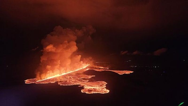 Volcanic eruption started at Sundhnúks crater row at 21:26 UTC, 22 August. This photo is taken one hour after the eruption started and the eruption fracture is estimated approximately 4 km long. Photo: Björn Oddsson/Civil Protection.
Volcanic eruption has started at Sundhnúks crater row
Updated 23. August at 10:00 UTC
The vigor of the eruption has decreased somewhat since its peak yesterday.
The activity is now mostly confined to two fissures, the northern end of the fissure that erupted first and the fissure that opened north of the first one.
Seismicity decreased rapidly after 04:00 UTC. However, ground extension continues north of Stóra-Skógfell, which suggests that the eruption has not reached equilibrium.
The data from tonight is being reviewed and new information will be provided as it is received and interpreted.
Updated 23 August at 01:00 UTC
The length of the eruptive fissure appears to remain the same for the last hour (approx. 3.9 km).
The seismicity is fairly stable, and the main activity is at the northern end of the eruptive fissure. It is therefore unlikely that the fissure will extend to the south. It cannot be ruled out that the eruptive fissure could extend to the north.
The lava flow continues both to the east and west towards Grindavíkurvegur. No lava flow is observed to the south towards Grindavík.
The Coast Guard will carry out another surveillance flight later tonight.
The next update will be provided tomorrow morning. IMO maintains a 24-hour monitoring of all natural hazards and will publish posts on Facebook later in the night with the latest information about the volcanic activity.
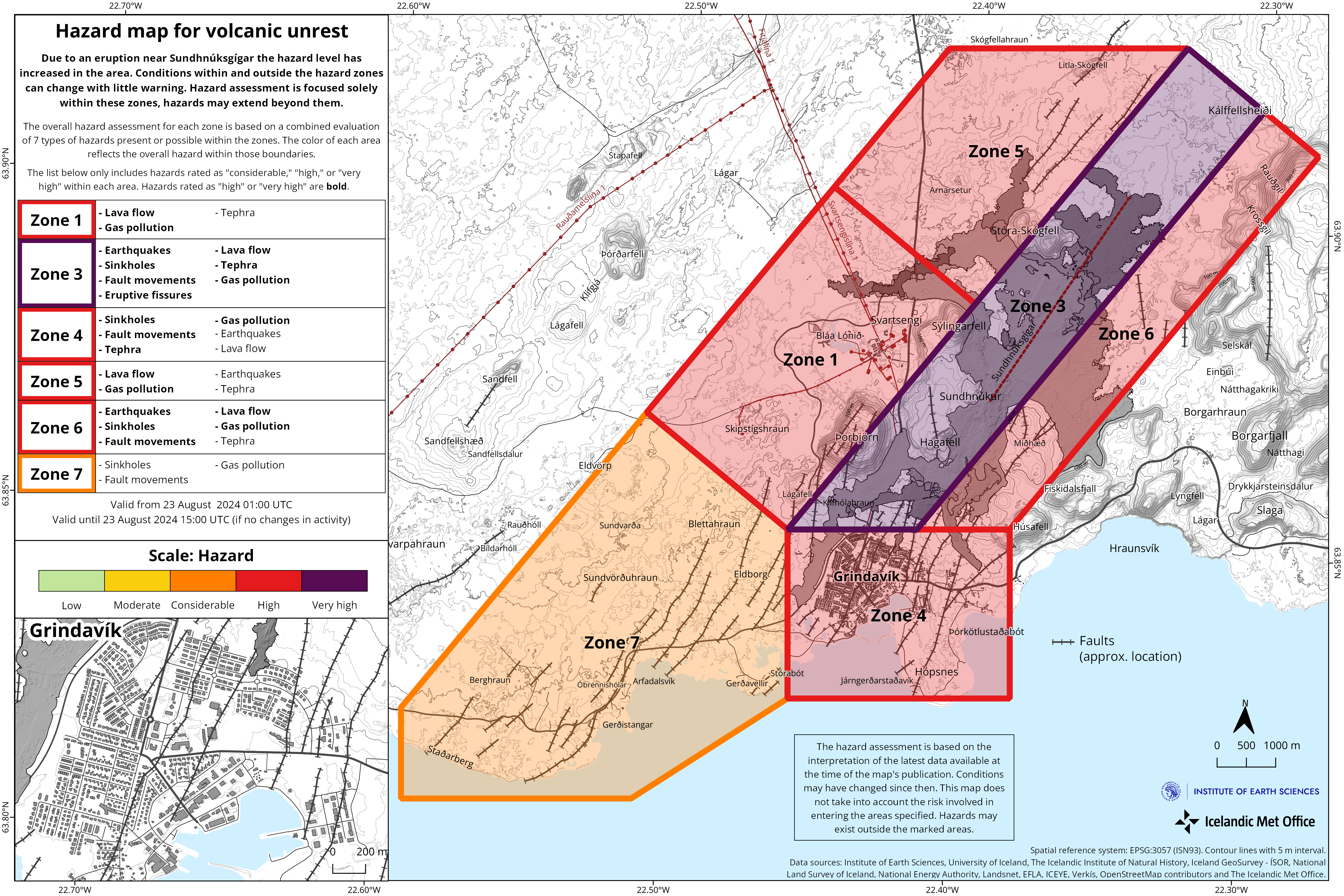
IMO has updated the hazard assessment which is valid until 3 P.M. today, Friday, August 23.
Updated 22 August at 11:25 UTC
IMO provides a gas distribution forecast. North and northwesterly winds are forecast tomorrow in the eruption area tomorrow. Gas pollution will spread to the south and southeast.
Updated 22 August at 10:54 UTC
The eruptive fissure now extends as far north as the eruptive fissure from the December 2023 eruption.
Updated 22 August at 10:45 UTC
Seismic activity continues at the northern end of the fissure. At 10:37 P.M. an earthquake of M4 was detected. It originated about 3 km northeast of Stóra-Skógsfell. Lava flows to the east and west. There is no lava flow towards Grindavík.
Updated 22 August at 10:30 UTC
The eruptive fissure has extended to the north. The total length of the fissure is now about 3.9 km, so it has lengthened by 1.5 km in approximately 40 minutes.

Updated 23 August at 01:10 UTC
The length of the eruptive fissure appears to remain the same for the last hour (approx. 3.9 km).
The seismicity is fairly stable and the main activity is at the northern end of the eruptive fissure. It is therefore unlikely that the fissure will extend to the south. It cannot be ruled out that the eruptive fissure could extend to the north.
The lava flow continues both to the east and west towards Grindavíkurvegur. No lava flow is observed to the south towards Grindavík.
The Coast Guard will carry out another surveillance flight later tonight.
The next update will be provided tomorrow morning. IMO maintains a 24-hour monitoring of all natural hazards and will publish posts on Facebook later in the night with the latest information about the volcanic activity.
IMO has updated the hazard assessment which is valid until 3 P.M. today, Friday, August 23rd .
Updated 22 August at 21:50 UTC
The eruptive fissure initially expanded both to the north and to the south. The length of the fissure has not been estimated at this point. Currently, no seismic activity is detected south of the eruptive fissure. The seismic activity is mainly to the north, which indicates that the magma is breaking its way to the north rather than to the south.
Updated 22 August at 21:26 UTC
A volcanic eruption has begun. A fissure has opened east of Sýlingarfell and by 9:30 a gas plume which reached approximately 1 km height dispersed to the south.
Updated 22 August at 21:25 UTC
At 20:48 UTC an intense earthquake swarm started in the Sundhnúkur crater row between Stóra-Skógfell and Sýlingarfell.
Increased pressure has also been measured in boreholes. These are clear signs that a dyke propagation has started and it is likely that an eruption is imminent.
- CategoriesEdited | All Content | Disasters | Earthquakes | Volcanos | Government | Science | Europe | Atlantic Ocean | News -- WNT Selected
- Date rangeFriday, August 23, 2024
- Last modifiedSunday, September 01, 2024
