Iceland Volcano: Eruption Continues
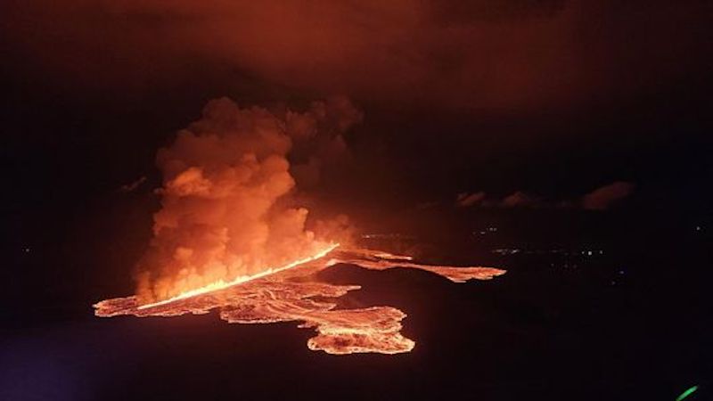 Volcanic eruption started at Sundhnúks crater row at 21:26 UTC tonight, 22 August. This photo is taken one hour after the eruption started and the eruption fracture is estimated approximately 4 km long. Photo: Björn Oddsson/Civil Protection.
The main activity occurs at two sites North of Stóra-Skógfells
The intensity of the eruption has decreased significantly since yesterday
The main activity is now limited to two areas
The most active fissure is the one which opened during the night
No activity south of Stóra-Skógafell
The seismic activity and ground deformation rate at the eruption site has slowed down. Today (23 August) the eruptive activity has been primarily occurring north of Stóra-Skógafell.
According to information from the Icelandic Coast Guard's surveillance flights, that flew at midday today, the main activity is limited to two areas north of Stóra-Skógafell.
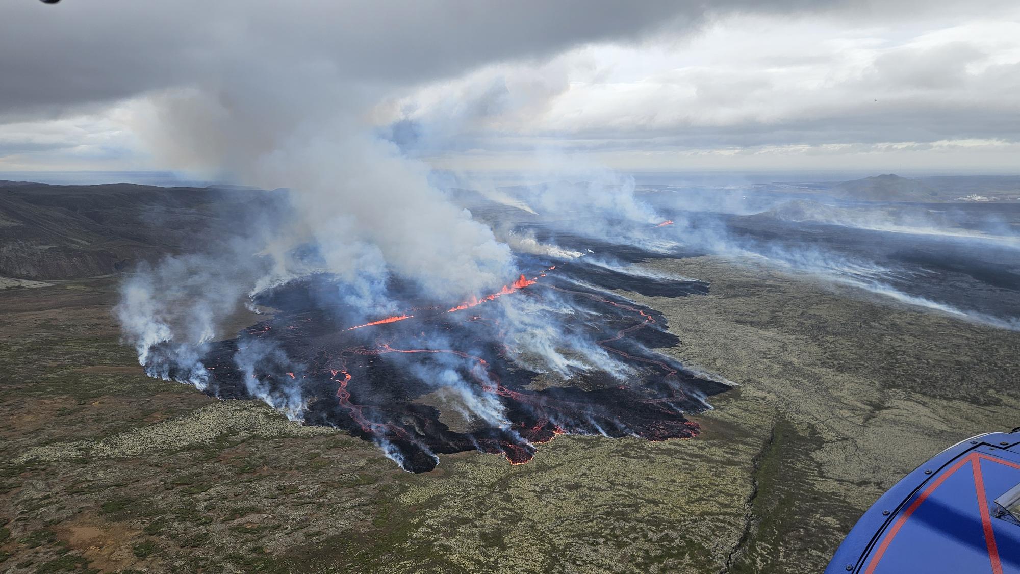 A photo from a surveillance flight taken by the Icelandic Coast Guard just after noon today, looking over the northernmost part of the eruption fissure. (Photo: Almannavarnir/Björn Oddsson)
The fissure that opened at the beginning of the eruption is now characterized by very low activity. Only a small fissure appears to be erupting on a small section directly east of Stóra-Skógafell. Activity seems to be reducing to a few demarcated areas, as happened in previous eruptions. The lava tongue that approached the Grindavíkurvegur road at the beginning of the eruption has therefore almost stopped.
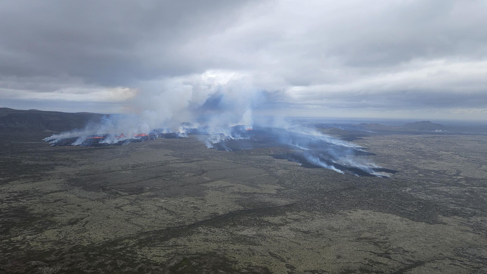 A photograph from the Icelandic Coast Guard's surveillance flight this morning. Looking south. Þorbjörn and Svartsengi can be seen in the distance on the right side of the picture. (Photo: Almannavarnir/Björn Oddsson)
Most of the flow of lava has been progressing to the northwest, as can be seen in the above photograph and the map that was published before noon in the previous news.
The propagating lava flow is causing extended wildfires in the area. The pollution caused by this eruption is transported fast to the south. Satellite images from today (Sentinel 5p) show the SO2 cloud traveling farther than 1,000 kilometers toward Scotland. See for more information on gas pollution forecast in the coming days.
Updated hazard assessment
The Icelandic Met Office has updated the hazard assessment in the light of the latest data and observations. The main changes are due to the low level of seismicity and deformation in the area detected south of Stóra-Skógafell. As no lava flows are propagating to the south, the hazard associated with lava flow invasion has been also reduced in the areas south of Sunhnúks.
The main change from the last hazard assessment is the hazard level for area 4 - Grindavík - which has been lowered from red to orange.
The hazard assessment is valid until 15:00 UTC, Monday 26 August, if the level of activity will be unchanged.
 (Click on the map to see it larger)
Updated 23 August at 12:00 UTC
The eruptive fissure is located further north than in previous eruptions.
Seismic activity and deformation significantly decreased after 4 AM this morning.
Gas pollution from the eruption will spread south and southeast today and tomorrow.
The hazard assessment will be updated later today.
At the onset of the eruption, the fissure opened between Stóra-Skógfell and Sundhnúkur, similarly to previous eruptions. During the first few hours, the fissure steadily extended northeast from Stóra-Skógfell until between 5 and 6 AM this morning. As the eruptive activity migrated northeast, there was a reduction in activity along the southern end of the fissure, with the eruption now taking place along a fissure that runs 2-3 km northeast from Stóra-Skógfell. The currently active fissure is located slightly farther north than the other eruptions that have occurred in this area since December 2023.
As the activity on the eruptive fissure shifted northward, the lava flow advancing towards Grindavíkurvegur, north of Svartsengi, slowed. The primary lava flow is now moving to the northwest, north of Stóra-Skógfell.
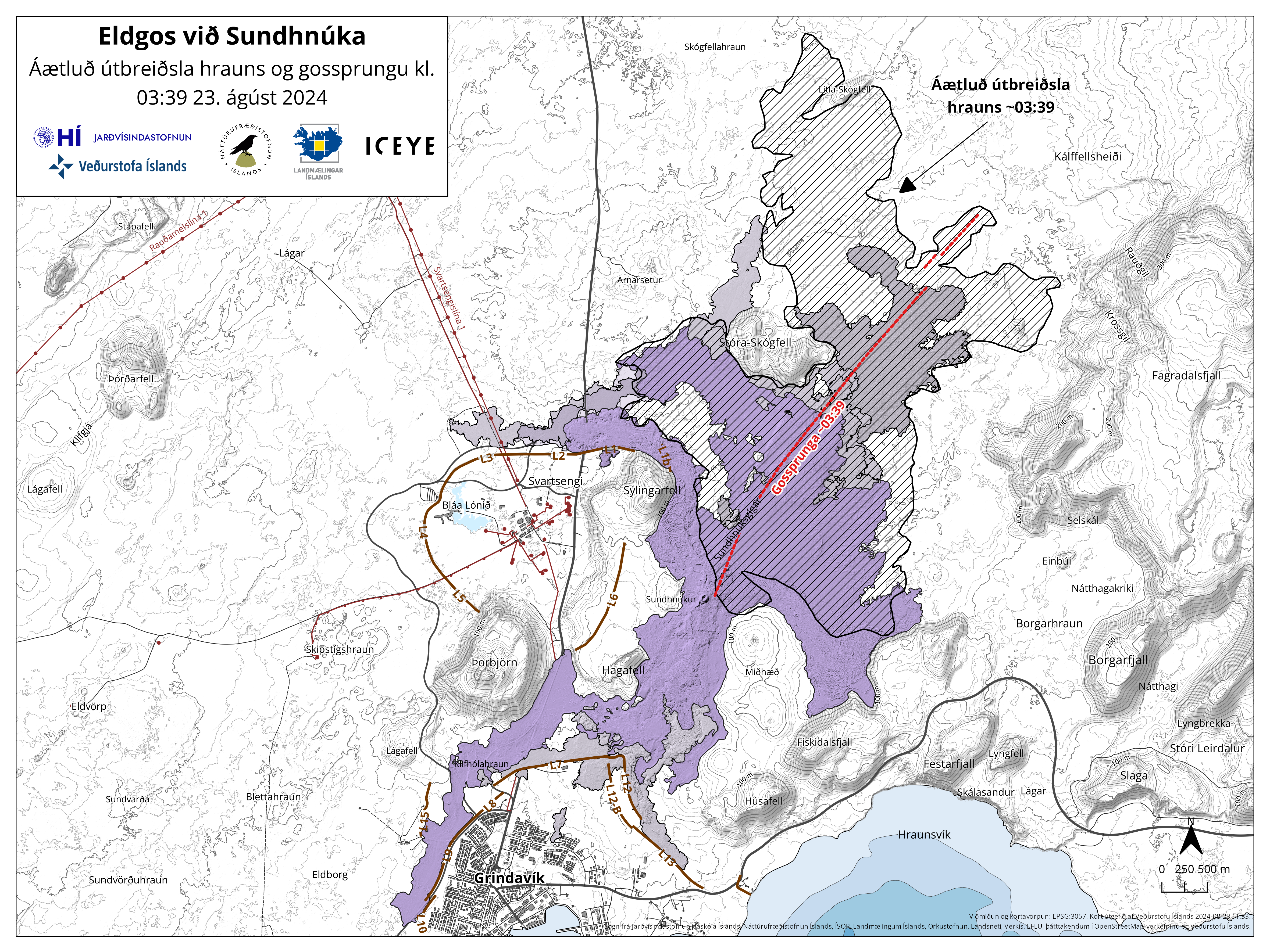 Map showing the extent of the lava flow (hatched area) formed during this eruption and the location of the eruptive fissure (red line) as it was at 03:39 last night. Also shown are the lava fields that have formed in the area since December 2023 (purple layers). The map is based on data from the IcEYE satellite.
As the eruptive fissure extended, significant seismic activity and deformation were recorded around the fissure. After 4 AM, seismic activity significantly decreased, and the rate of deformation decreased, which corresponds with the development of the fissure. Despite this deceleration, deformation is still ongoing in the area.
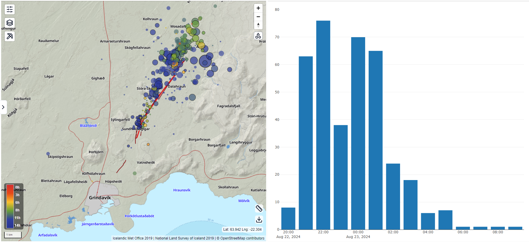 On the left is a map showing an overview of the development and location of earthquakes around the Sundhnúkar Crater Row from 8:00 PM last night to 11:00 AM today. On the right is a bar graph exhibiting the number of earthquakes recorded each hour.
There will be northerly and northwesterly winds at the eruption site until tomorrow evening. Therefore, gas pollution from the eruption will spread south and southeast. You can monitor the gas dispersion forecast on our website.
- CategoriesEdited | All Content | Disasters | Earthquakes | Volcanos | Government | Science | Europe | Atlantic Ocean | News -- WNT Selected
- Date rangeFriday, August 23, 2024
- Last modifiedSunday, September 01, 2024
