Iceland Volcano: Steady Magma Accumulation Under The Svartsengi Region -- Iceland Met Office
 A picture taken June 22 into the one crater that remained active until the end of the eruption that began on May 29. (Photo: Civil Defense)
Increased likelihood of a new dike intrusion and an eruption in the coming weeks. Updated scenarios released alongside a revised hazard assessment.
Updated 23 July at 18:00
- Based on the volume loss observed during diking on 29 May, and continued subsidence during the first week of the May-June eruption, it is estimated that a volume between 13 to 19 million cubic meters needs to be recharged before the next event is triggered
- According to model calculations, the total recharge volume is likely to approach 16 million cubic meters in the coming days
- A new magma intrusion and an eruption is considered highly probable within the next two to three weeks
Hazard map and scenarious have been updated
In recent days, seismicity in the Sundhnúks crater row has been relatively low, although slowly increasing. Ten micro-earthquakes have been detected in the crater row in the last 24 hours, and about 90 in the past week. Most of the earthquakes are below magnitude one and are distributed along the crater row. By comparison, over 50 earthquakes were recorded daily in the lead-up to the last eruption. Over the past few weeks, seismic activity is slowly increasing day by day, in line with the continued accumulation of magma within the Svartsengi reservoir.
Ground deformation continues, and magma accumulation under Svartsengi has persisted at a steady rate in recent weeks. Based on the volume loss observed during diking on 29 May, and continued subsidence during the first week of the May-June eruption, it is estimated that a volume between 13 to 19 million cubic meters needs to be recharged before the next event is triggered. According to model calculations, the total recharge volume is likely to approach 16 million cubic meters in the coming days. There is some uncertainty in these calculations, but a new magma intrusion and an eruption is considered highly probable within the next two to three weeks, provided the magma inflow rate to the Svartsengi reservoir remains stable.
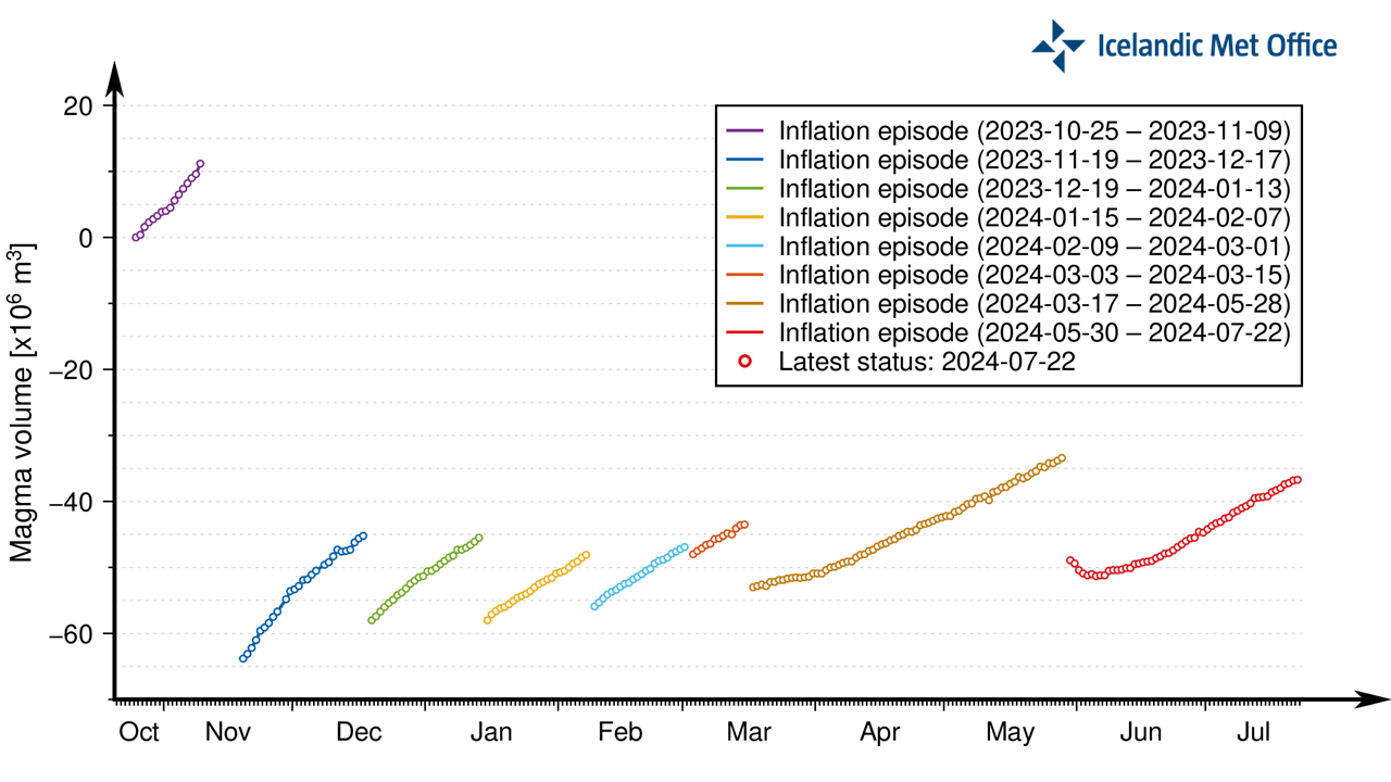 A graph showing the development of magma accumulation and the estimated total volume change within the Svartsengi magma reservoir since 25 October 2023, which includes episodes of volume loss from the reservoir (during diking events) and volume recharge following these events.
 The graph shows the estimated volume change related to magma accumulation within the Svartsengi reservoir between dike intrusions since November 2023.
"All our geodetic measurements and modeling results indicate that magma accumulation under Svartsengi is continuing at a steady pace," says Michelle Maree Parks, a volcano deformation expert at the Icelandic Meteorological Office. "It is not unusual to see fluctuations in uplift between daily measurements. It is important to look at the overall picture based on both vertical and horizontal GNSS measurements, satellite images, and models spanning a longer period. In recent weeks, there are no indications in our data or models that suggest any significant changes to magma inflow to the Svartsengi reservoir. Provided the inflow rate remains stable we can expect a new dike intrusion and an eruption in the next two to three weeks," says Michelle.
Updated hazard assessment and scenarios
 The Icelandic Meteorological Office has updated the hazard assessment considering the likelihood of a new magma intrusion and an eruption in the coming weeks. The hazard level has been raised in all areas except in zone 7. The hazard assessment is valid until 30 July, unless conditions change.
Updated scenarios in the event of an eruption
The Icelandic Meteorological Office has updated the scenarios considered most likely if an eruption occurs. Both scenarios are considered equally likely, and they assume that the initial intensity of the next eruption will be similar to the eruption in May-June 2024.
Scenario 1 - Eruption between Stóra-Skógfell and Sundhnúkur (central part of zone 3 on the hazard assessment map). Similar location to eruptions that began on 18 December 2023, 8 February, 16 March, and 29 May 2024.
- The likely precursor is a localized earthquake swarm between Stóra-Skógfell and Sýlingarfell, acceleration in deformation, and pressure changes in boreholes in the area.
- Very short pre-eruption warning time (less than 30 minutes).
- Lava could reach Grindavíkurvegur near Þorbjörn within 1.5 hours and Grindavíkurvegur near Svartsengi within 3 hours.
Scenario 2 - Eruption south of Sundhnúkur, near Hagafell, and extending south towards and potentially within northern Grindavík (southern part of zone 3 on the hazard assessment map and the northern part of zone 4). Similar location to the eruption that began on 14 January 2024.
- The likely precursor is an earthquake swarm starting near Stóra-Skógfell or Sýlingarfell and moving south, acceleration in deformation, and pressure changes in boreholes in the area.
- The warning interval for an eruption in this area would probably be longer than in scenario 1, but it is uncertain by how much. The length of the warning period depends on how far south the magma must break a pathway to the surface.
- Lava could reach Nesvegur and Suðurstrandarvegur within 1.5 hours. Lava flows could potentially close escape routes on land within about 6 hours.
- In this scenario, lava could reach the sea east of Grindavík within 1.5 to 3 hours. If lava reaches the sea, it could cause localized hazards due to rapid cooling of the lava. Initially, there would be a hazard due to ash and gas formation, primarily hydrochloric acid (HCl). Within a radius of about 500 meters from where the lava enters the sea, conditions would be life-threatening.
- A magma intrusion that reaches south of Hagafell will likely cause significant fault movements in Grindavík.
- There is a possibility that lava could erupt within Grindavík. One scenario is that lava erupting from a vent north of the protective barriers at Grindavík could flow into existing fissures and then re-emerge again within the town limits. Another scenario is the possibility of an eruptive fissure opening within Grindavík. However, in such a situation, it is likely that a fissure would first open north of the town before opening within the town limits.
"The scenarios we present today are based on the latest data and analyses, and they raise concerns that lava could reach within the protective barriers at Grindavík," says Matthew J. Roberts, Managing director of the Service and Research Division at the Icelandic Meteorological Office. "We must therefore be prepared for the possibility that lava erupting from a vent north of the protective barriers above the town could flow into the fissure system south of Hagafell and lead the lava flow within the town limits," says Matthew.
"Experience from the January 2024 eruption tells us that we cannot rule out the possibility of an eruptive fissure opening within Grindavík. But in such a case, it is most likely that a fissure would first open north of the town before a fissure opens within the town limits."
"In addition, lava flow models show that if an eruption occurs near Hagafell, lava flow could close escape routes on land out of the town within a few hours after the eruption starts," says Matthew.
- Categories
- Date rangeTuesday, July 23, 2024
