Iceland Volcano: Eruption North Of Stóra-Skógfell Is Over -- Iceland Met Office
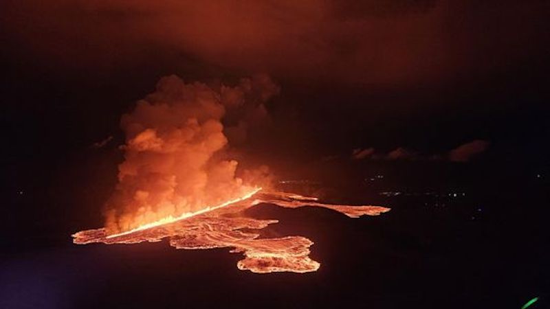 Volcanic eruption started at Sundhnúks crater row at 21:26 UTC tonight, 22 August. This photo is taken one hour after the eruption started and the eruption fracture is estimated approximately 4 km long. Photo: Björn Oddsson/Civil Protection.
The hazard map has been updated
Updated 6. September at 16:00 UTC
- No visible activity at the craters since yesterday evening
- Ground uplift has started again in the Svartsengi area
- The eruption lasted 14 days
- The hazard assessment is updated
The eruption which commenced on 22 August is now declared over, hence the hazard assessment has been updated. The main changes affect Zone 3, where the eruptive fissures opened at the beginning of the eruption. Zone 3 is now assessed to be at high hazard level (red) since the likelihood for vent openings, gas pollution and tephra fallout are assessed to be lower than before. Zone 6 is now assessed to be at considerable hazard as the likelihood of gas pollution is reduced. Within Zone 1 (Svartsengi) hazards are assessed to have either low or very-low likelihood.

Ground uplift has started again in the Svartsengi region indicating that magma has started accumulating within the magma body at 4-5 km depth. IMO will continue monitoring the ground deformation rate, but preliminary results from geodetic modelling indicate that the magma is accumulating at a rate which is like those estimated in periods which followed the end of previous eruptions.
 The sketch shows the ”closed” system when the magma flows from depth (red arrow) into the Svartsengi reservoir to a shallower level at 4-5 km (orange domain) causing an increase in pressure and measurable ground deformation at the surface.
- Categories
- Date rangeFriday, September 06, 2024
